


Cruising the Thames
Steve Davies of North Kent Yachting Association reflects on the attraction of a different destination, plus a relatively low-cost way to stay in central London.
The River Thames provides an interesting mix of open water, scenery and industrial activity, as well as examples of our industrial heritage, yet it is visited relatively little by yachts. A visitors’ berth in St Katharine Docks or Limehouse Marina makes a reasonably cheap base to see the sights of London. If you are a motor boat owner, or can lower your mast, you can even head on through central London and out the other side. Above Teddington Lock the Thames is non-tidal and navigable for 70 miles deep into Gloucestershire at Lechlade.
The Tidal Thames is managed by the Port of London Authority (PLA). Its main website is biased towards commercial shipping but includes some information of general interest. Of far more value is the PLA’s www.boatingonthethames.co.uk, aimed specifically at leisure users. It has a lot of downloadable information, including full tide tables for various points on the river. The Recreational Users’ Guide is a useful overview of the river, and is available printed on waterproof paper. Have a good look at the site; there are a number of videos covering passages along various parts of the river, and much other useful information. If you are on the move, download the PLA app, which gives live tidal data and faster access to much of its website content. You’ll find these and some other websites and books listed at the end of this article.
The Thames can provide some interesting challenges, although none are a problem if you’re prepared. Everything revolves around the tide, which can reach 3–4kts in places. There’s a significant amount of commercial traffic—the Port of London is the busiest inland waterway in the country. This traffic is confined to the deep-water channels (although signals indicating this are usually not displayed), and it’s up to you to keep out of its way – there’s usually plenty of room for you outside the channels. Don’t forget that many large commercial vessels have poor visibility dead ahead.
The nature of the bottom varies significantly; from the vast expanse of shallow water over the Cant, to the mudflats of the Blyth Sands, which are covered at high water, to deep channels that shelve steeply at the edges. The channels are well buoyed until you’re beyond Gravesend, so it’s quite straightforward to keep track of your position.
There are few casual moorings on the Tidal Thames; however it’s usually possible to find a free swinging mooring at one of the clubs. The PLA also has some moorings, and may be able to point you to other moorings if you call them up.
The whole of the Thames from the outer port limit to Teddington Lock is monitored by the PLA from its control centres at Gravesend and the Thames Barrier, supported by the harbour service launches. Commercial traffic has to report in at various points, so it’s well worth monitoring the port channels — 69 in the outer estuary, 68 in the inner estuary and 14 from the Barrier area—to get an idea of traffic. While there is no need for yachts to call up (except to pass through the Thames Barrier), the PLA is very happy for you to do so, and can advise on traffic movements. There are also half-hourly broadcasts of traffic, tides and other relevant information.
Approaching the Thames
There are three main routes into the Thames, with the choice usually being determined by your starting point. If coming down the East Coast from the Blackwater, the Walton Backwaters and beyond, there’s a well-trodden route along the edge of the Maplin Sands. It’s also possible to bypass the outer estuary by coming through Havengore Creek from the River Roach and the River Crouch. This is not ideal because it leaves you just off Southend at high water.
From Holland and Belgium and places north, there are the channels used by larger shipping vessels (keep to the edges). These are separated by sandbanks, which in some cases dry completely. Finally, if coming from the South Coast or France, you come past Ramsgate, round North Foreland and past Margate, along the channels of the north coast of Kent. The area is beset with wind farms, although they are not generally a hazard.
Once past Southend, the Recreational Users’ Guide shows the preferred route for small craft. Make sure you’re on the south side of the deep water channel before you get to the East Blyth cardinal—but watch the depth sounder and don’t stray onto the Blyth Sands. This route takes you away from the London Gateway, the newly built container port able to take some of the largest ships. Occasionally you’ll meet one of these across the channel. You may also meet small fishing boats.
Heading up river
Round the corner, Lower Hope Reach can be a bit choppy in wind-over-tide situations, but only until you enter Gravesend Reach. Here, larger commercial traffic sometimes slows down to change pilots and this is where monitoring the port VHF channels can be very helpful. You may notice the copper gleam on the roof of the Sikh temple, and the flagpole of Gravesend Sailing Club, on the South shore.
Above Gravesend the river narrows and the constricted traffic becomes very busy. It is well worth listening to Channel 68 to see what commercial traffic to avoid. If in doubt, call ‘London VTS’ for information.
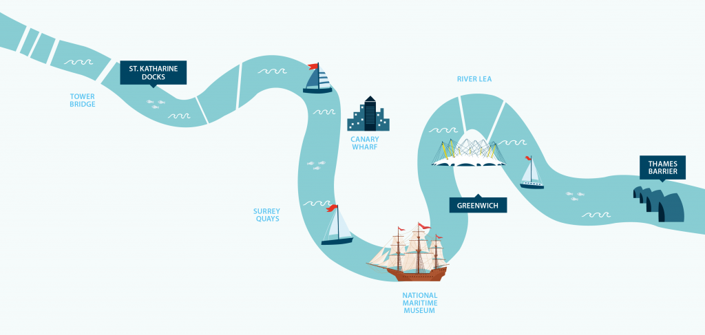
The river continues to meander in a series of ‘reaches’ and bends. The commercial and industrial landscape is interspersed with more domestic stretches and the occasional ‘boaty’ intrusion such as the Thurrock Yacht Club and Erith Yacht Club. Apart from the traffic, navigation hazards are few, but beware the back eddy past Erith Yacht Club on the south side. You’re now well on the way to the Woolwich Barrier. Once within sight of it, you need to call Barrier Control on Channel 14 to request permission to pass through. You will be told to use the northernmost open span, marked with big green arrows. Turn on your engine at this point; sailing through the Barrier is strongly discouraged (with good reason). Keep in the centre as you pass through the piers, since there is a strong flow. Greenwich YC is immediately after the Barrier on the south side; their Clubhouse is on the end of a jetty.
Hereafter it is best to keep motoring if you can. There are increasing numbers of tall buildings creating wind eddies and flat spots, which make sailing difficult. There is also an increasing amount of passenger-boat traffic, some of which is exempted from the 12kt speed limit and travels much faster. They often criss-cross the river, as they call at the various piers.
A series of tight bends enclose the Isle of Dogs and Canary Wharf and landmarks now come thick and fast. At the start is the Emirates Air Line cable car across the river, then Bow Creek, the O2, the spectacular Royal Naval College at Greenwich, the National Maritime Museum and the Cutty Sark.
You are now in the approach to Limehouse Marine on the north side of the river. If this is the end of your journey, let the lock-keeper know you’re there (VHF M2); it’s generally best to stem the tide just off the entrance, rather than mooring to the waiting pontoon, because of the wash from passing vessels. When leaving Limehouse, especially at mid-tide, leave fast and always turn up river initially, so that you don’t impede other vessels heading up.
Limehouse Waterside & Marina provides access to most of the English canal system and central London is easily reached using the Docklands Light Railway. On the doorstep is the Cruising Association. The visitor fees are £6.80 per metre per night, subject to availability.
If you carry on to St Katharine Docks, you may come across canal boats heading through central London. Limehouse Marina is one end of the Regent’s Canal and the Lea navigation, while to the west, Brentford is the start of the Grand Union. Round the corner past the River Police at Wapping, Tower Bridge appears ahead of you. The St Katharine Docks entrance is just before the bridge. Keep close in to the north to avoid through traffic, especially when waiting for the lock, or use one of the waiting buoys. Once in the Haven you can moor up and relax, and start to enjoy the sights, many of which are only a short walk away.
Caution: the tide runs fast past the entrances to both Limehouse and St Katharine Docks. For both entering and leaving it is best to wait for slack water. There is a sharp cut-off between the fast tide flow and still water in the lock mouth, which can spin a boat startlingly. Keep plenty of way on in both directions. And enjoy your time on the Thames!
Steve Davies, North Kent Yachting Association